
OVER 2,000 BOAT DETECTIONS IN PROTECTED AREAS OF CYPRUS - WHAT SATELLITE MONITORING REVEALS IN LATSI-AKAMAS, CAPE GRECO AND LADY'S MILE - Filenews 5/10
More than 2,000 vessel detections were recorded in the summer of 2024 and 2025, through satellite monitoring in the Lady's Mile, Latsi-Akamas and Cape Greco Marine Protected Areas, with more than half of them not corresponding to an available AIS signal. The findings highlight recurring patterns of activity and significant gaps in the monitoring of sensitive coastal areas of Cyprus.
Specifically, satellite observations recorded 2,060 vessel detections in the areas of Lady's Mile, Latsi-Akamas and Cape Greco during selected summer seasons of 2024 and 2025, offering a new insight into environmental pressures within three of the most important Marine Protected Areas (MPAs) of Cyprus. As stated in a press release, these areas protect ecologically valuable coastal habitats, including the underwater meadows of the Posidonia oceanica plant, which are important breeding and feeding grounds for marine species, support biodiversity and contribute to coastal protection and carbon sequestration. As this particular marine plant grows very slowly, damage can occur in a matter of seconds and persist for decades, which makes it particularly important to prevent it.
The analysis leveraged the vessel detection service using Artificial Intelligence of PERIOPSIS LTD, which relies on visible spectrum satellite imagery to identify vessels at sea. The detections were compared with data from the Automatic Identification System (AIS), a tracking system through which ships transmit information about their identity and course. Of the 2,060 detections, 1,114 — about 54% — did not correspond to an available AIS signal, revealing a significant gap in tracking between what could be observed from space and what appeared in conventional tracking systems. This finding underscores the importance of remote sensing in such research.
Satellite images do not reconstruct the full course of each vessel, but they do show the repeated presence of vessels and the areas where activity is concentrated. Since the analysis is based on one satellite survey per day, the actual number of detections may be significantly higher than the 2,060 recorded. In combination with AIS data and patrols, satellite monitoring can help to form a more complete picture of activity in sensitive marine waters and to identify persistent monitoring gaps.
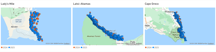
In Latsi-Akamas most of the detections
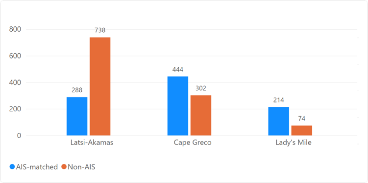
The Latsi-Akamas MPA was the area with the most frequent presence of vessels out of the three, accounting for almost half of all detections and showing the highest activity during satellite observation days in both years. In the Latsi-Akamas area, 1,026 detections were recorded, of which 738 did not correspond to an AIS signal. In Cape Greco, 746 detections were recorded, of which 444 corresponded to AIS data and 302 did not match. At Lady's Mile, 288 detections were recorded, with 214 corresponding to AIS and 74 unmatched. Unmatched detections in AIS may be related to legitimate activities, such as tourism and the use of yachts or other uses. However, they can also indicate unreported or potentially illegal activity at sea, including fishing, transporting goods or other activities. The differences between the sites show why monitoring should be tailored to the specific characteristics of each protected area. Time series charts also show that July and August show increased activity compared to June.
In the three MPAs, detections during the July-August period were about 17% lower in 2025 compared to 2024, with the largest decrease recorded in the Lady's Mile, while activity in Cape Greco remained broadly stable. During the summer season, lower activity was observed in June, with an increase in July and August, taking into account differences in the number of days of satellite observation. Overall, August saw the highest level of vessel activity in both years.
Comparing the same period between the two years, the observed activity decreased in the areas of Latsi-Akamas and Lady's Mile in 2025, while in Cape Greco it remained broadly stable.

Of particular importance is the fact that about 60% of the detections in the sample concerned vessels classified as non-moving at the time of observation. While this does not confirm that the vessels were anchored, it does allow for the identification of areas that may need closer monitoring.
The issue is particularly important for the protected Posidonia meadows, which are a priority habitat. Anchors and chains can put a strain on Posidonia meadows when they are repeatedly thrown or dragged to the bottom. Anchoring is recognized as one of the significant impacts of yachting activity in the MPAs of the Mediterranean. This pressure is also highlighted in WWF's reports on Mediterranean marine plant meadows, in which Cyprus is among the Mediterranean regions with the highest anchoring pressure.
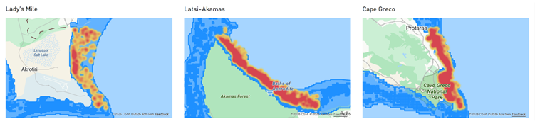
The combination of vessel activity maps with distribution maps of P. oceanica can highlight the areas where pressure from vessels may coincide with sensitive seafloor habitats. The heatmaps below show the points where the most activity is concentrated in the three areas.
The findings demonstrate how satellite technology, combined with Artificial Intelligence, can be leveraged for the daily monitoring of the sensitive marine areas of Cyprus, allowing the longitudinal identification of changing points of increased activity and persistent gaps in monitoring. As noted, satellite technology is not intended to replace patrols or existing vessel monitoring systems. It can, however, be complementary, providing an independent additional source of information and helping competent authorities and environmental protection organisations to focus their attention where there is a greater need.
These data, it is added, "can provide policymakers and environmental authorities with clear and documented information on the extent and spatial distribution of vessel activity within sensitive Marine Protected Areas. By making visible and measurable pressures that are otherwise difficult to observe, the research highlights the pressures exerted on protected habitats, such as Posidonia meadows, and contributes to more informed decisions on monitoring, enforcement, and management measures. The findings can also further document the need for early action so that the designation of an area as a Marine Protected Area translates into effective protection and long-term conservation outcomes in practice."
The study was carried out by PERIOPSIS Ltd, the Marine and Environmental Research (MER) Lab and Mr. Finn Lageveen, a student of the Creative Technology program at the University of Twente in the Netherlands.
