Filenews 19 November 2024
Quite beneficial were the rains we had over the weekend in all areas of Cyprus. "Alexander" fortunately did not cause any damage but brought good rains that we needed.
According to Kitasweather after the rains/thunderstorms observed in the last 4 days, the average rainfall rate for the month of November reached today Tuesday 19/11/2024 (08:00) to 128% from 65% until Friday 15/11/2024 (08:00).
The weather stations of Kitasweather have recorded the following total quantities from 08:00 (15/11) to 08:00 (19/11):
Jubilee Hotel – Troodos: 34.3 mm
Linos Winery – Omodos: 39.0 mm
Blue Arches – Lefkara: 16.5 mm
BMW – Strovolos Municipality, Nicosia: 18.5 mm
Spectus – Limassol: 36.1 mm
Lithos – Limassol: 28.2 mm
Sunfresh – Kato Paphos: 36.2 mm
Papantoniou – Polis Chrysochous: 47.0 mm
Taverna Stou Roussia – Larnaca: 16.0 mm
Dimosthenous Estate – Chapel: 51.2 mm
Smokeless: 36.9 mm
Youth Center Streets – Streets: 19.4 mm
Hotel Petit Palais – Platres: 26.5 mm
Meneou: 29.0 mm
Aradippou: 11.5 mm
Larnaca – Net area: 12.4 mm
Larnaca – Chrysopolitissa area: 13.7 mm
Oroklini: 8.7 mm
Tavern O Vrakas – Pissouri: 41.1 mm
Kellaki: 37.2 mm
The rainfall of the period (15/11/2024 – 19/11/2024 (08:00)), based on the meters of the Department of Meteorology, ranged from 5.9 mm (Athienou) to 99.1 mm (Kato Pyrgos Tyllirias). The total average rainfall over the last 4 days amounted to 33.6 mm.
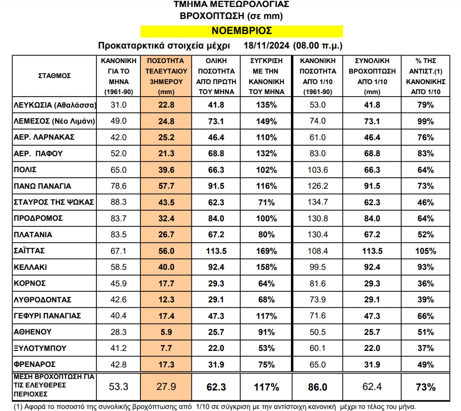
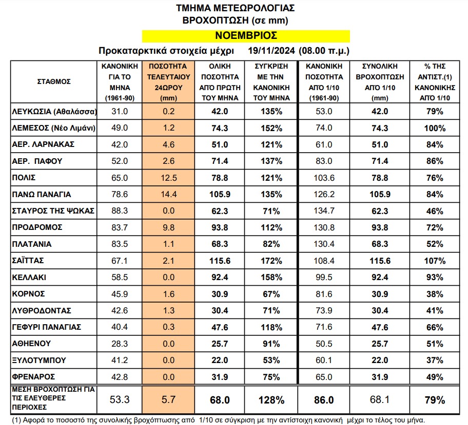
For the rest of the November measurements of the Department of Meteorology click here. https://www.dom.org.cy/CLIMATOLOGY/Greek/%CE%A0%CF%81%CE%BF%CE%BA%CE%B1%CF%84%CE%B1%CF%81%CE%BA%CF%84%CE%B9%CE%BA%CE%AC%20%CE%94%CE%B5%CE%B4%CE%BF%CE%BC%CE%AD%CE%BD%CE%B1%20%CE%92%CF%81%CE%BF%CF%87%CE%AE%CF%82/Daily%20Precipitation%20Data_%20November2024.pdf
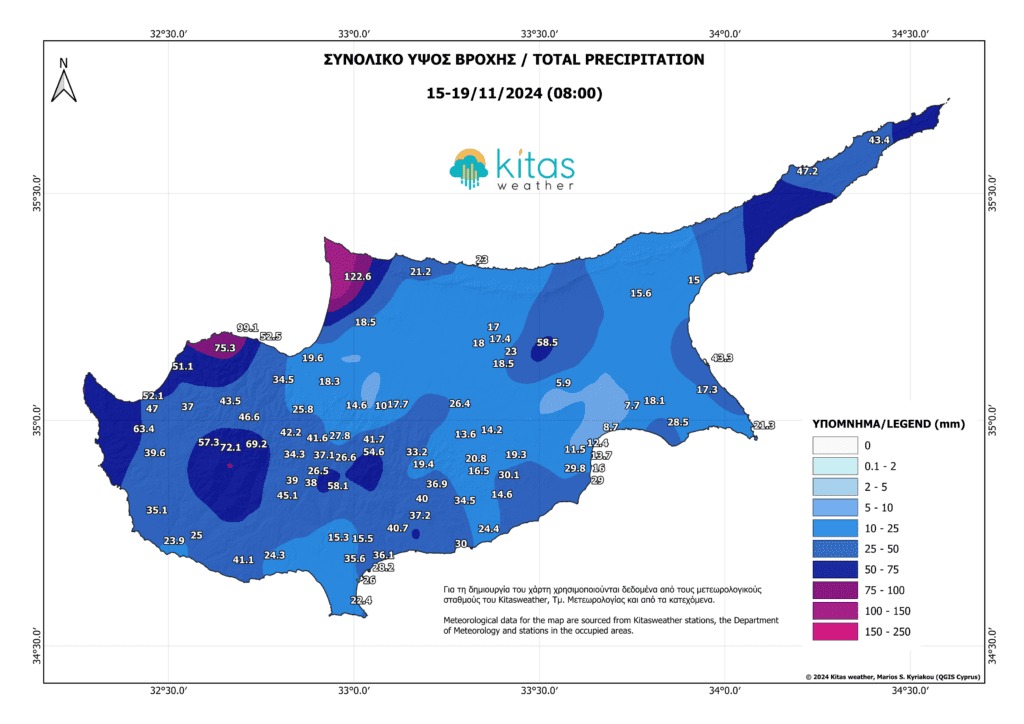
On the map below the creation of Kitasweather you can see the total rainfall heights that occurred on the island based on the measurements of Kitasweather, the Department of Meteorology and the occupied areas from 15/11/2024 (08:00) to 19/11/2024 (08:00).
For a better assessment of the period, we present below the total amounts of rain recorded by our meteorological stations (from 10:30 16/11/2024 to 08:00 19/11/2024):
Jubilee Hotel – Troodos: 32.5 mm
Linos Winery – Omodos: 39.0 mm
Blue Arches – Lefkara: 13.7 mm
BMW – Strovolos Municipality, Nicosia: 18.5 mm
Spectus – Limassol: 36.1 mm
Lithos – Limassol: 28.2 mm
Sunfresh – Kato Paphos: 36.2 mm
Papantoniou – Polis Chrysochous: 42.9 mm
Tavern Stou Roussia – Larnaca: 16.0 mm
Dimosthenous Estate – Chapel: 47.6 mm
Smokeless: 26.2 mm
Youth Centre Roads – Streets: 14.6 mm
Hotel Petit Palais – Platres: 26.5 mm
Meneou: 29.0 mm
Aradippou: 11.5 mm
Larnaca – Net area: 12.4 mm
Larnaca – Chrysopolitissa area: 13.7 mm
Oroklini: 8.7 mm
Tavern O Vrakas – Pissouri: 41.1 mm
Kellaki: 31.2 mm
In the images below you can see the rainfall heights that occurred all over Cyprus based on the measurements of Kitasweather, the Department of Meteorology and the occupied territories from 16/11/2024 (08:00) to 19/11/2024 (08:00) as well as the estimated precipitation map that we issued and was valid for 16/11/2024 (10:30) – 19/11/2024 (08:00)
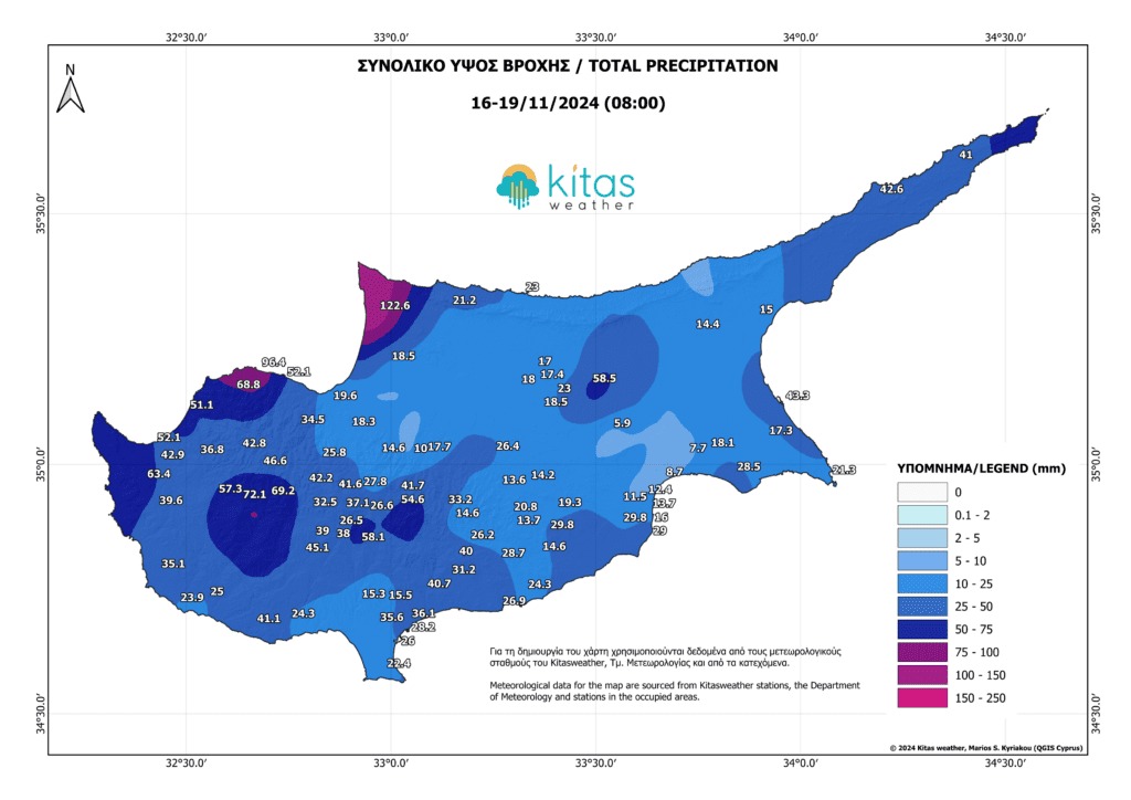
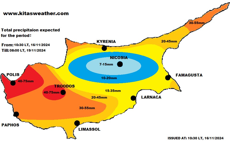
Based on the above data, the estimated precipitation map behaved very well in most areas of the island since rainfall heights ranged within the rainfall ranges we expected (from the lowest to the upper limits of the estimate and individually slightly above or slightly below these limits). The only small points where the map did not behave so well are 3 and which will be analyzed below:
- The wider area of occupied Kormakitis received much higher rainfall heights than we estimated (although we estimated several millimeters in this area), as the area of Agia Irini Kyrenia recorded 122.6 mm of rain during the three days. This particular area was favored by both several storms and several passages of rain.
- The wider area of eastern Nicosia and further east also received higher rainfall heights than estimated, with a maximum value of 58.5 mm in occupied Tymvos as severe thunderstorms occurred in this area during the midday/afternoon hours of Sunday. The bulletin said areas affected by severe storm epicenters or successive storms could write up to 10-20mm more than on the map, but just over 40mm of rain was recorded in that area.
- The wider area between Athienou – Xylotympou and eastern parts of the city of Larnaka received lower rainfall heights than we estimated as they benefited to a small extent from the generalized passage of rain at dawn on Sunday and then nothing significant was observed during the rest of the disturbance.
It should be noted that Kitasweather did not issue a warning about this disorder and we believe that we were right to do so. Although some isolated areas experienced fairly large amounts of rain, these were spread over a long period of time over the three days, without causing any particular problems. We also had no hail or gusty winds from the storms falling under the warning criteria.
As for the estimate we made that this disturbance would give us 20-30 mm of average rainfall, this was slightly exceeded and we got a total of around 32.5 mm of average rain (removed about 1 mm of average rainfall from Friday as our estimate was valid for the period Saturday (10:30) – Tuesday (08:00).
The inflow of water to the dams in the last 4 days amounted to 0.522 E.K.M of water. From October 1st until today, the total inflow was 1,497 E.C.M of water. The total occupancy of the dams remained stable at 25.2% on Tuesday (19/11) while on the same day last year it was at 46.7%
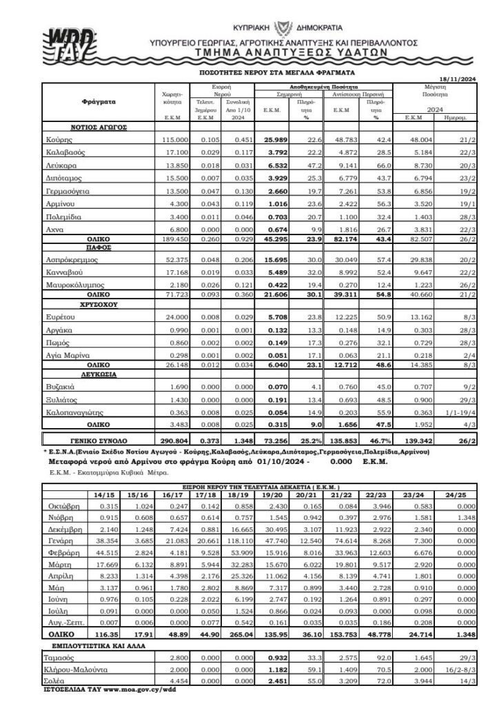
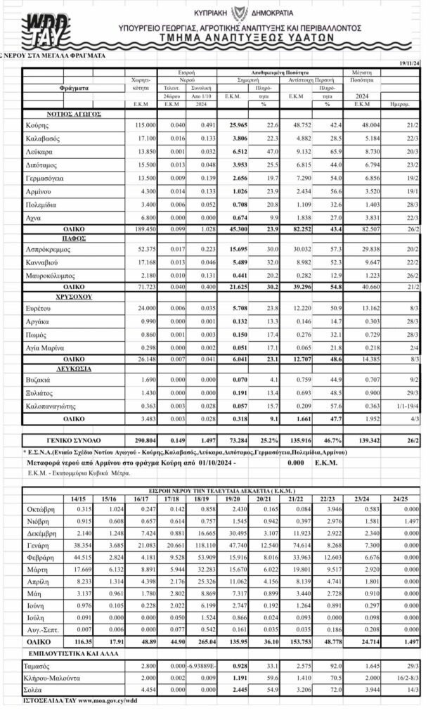
The rains of this disturbance again brought a small increase in water inflows to the dams, which although small are not bad for November (provided that a long period of drought has been observed). Nevertheless, these inflows are negligible in relation to the needs we need and the inflows are expected to decrease in the coming days. To initiate appreciable water inflows into dams, we will need extensive very appreciable rainfall heights (around 100 mm of average rainfall and above) in the dam basins.
By kitasweather
