Filenews 29 June 2024

Things seem to be worse in Pissouri from a geological point of view, than initially estimated, and some pieces of land that were included in a white zone (in which any building activity is temporarily prohibited) may be permanently lost, in the sense that it is possible to make permanent the ban on the construction of buildings.
Although various studies are ongoing (some have already been completed), some data are of great concern to the relevant government departments.
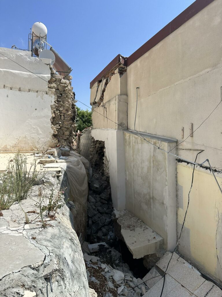
These data refer to tectonic faults that exist in the area, combined with the fact that sinkholes also appeared. In general, those responsible are concerned with the complex geology of the area. Some of these data were known, but the extent of their impact had not been estimated, because over time the emphasis had been given to research related to the wider interest of the place, such as the control of the soil/subsoil in the areas where the dams were created, airports, in areas where there was a high population density, etc.
What the competent authorities are seeking, given that any decision may affect (positively or negatively) perhaps hundreds of houses (some of them of great value), is to prepare the necessary studies so that there is a clear picture of the prevailing situation, so that the most appropriate projects can be carried out under the circumstances. As it is known, the creation of a pile wall had been planned in order to stabilize the subsoil and stop the phenomenon of landslide, but the project (which until then cost €8.5 million) was frozen, following suggestions by ETEK.
The Chamber suggested that further studies should be carried out in order to identify the problem that causes the landslides and then implement any projects, otherwise there is a risk that the pile wall will not bring the desired results, which will constitute a waste of public money. It is noted that both phases of the project would cost approximately €33 million.
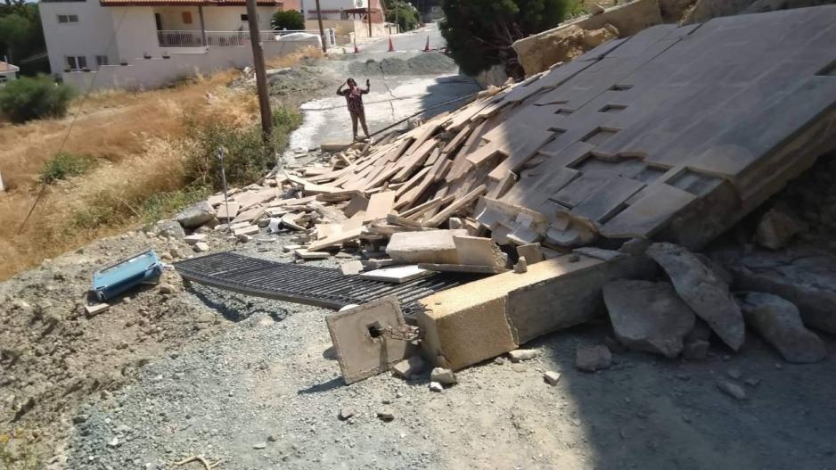
A public official with whom we contacted said that if the problem of landslides is not resolved, hundreds of houses are threatened. In addition to the reported houses threatened by a continuation of the landslide phenomenon, so far there has been serious damage to about 50 houses, of which 30 have been destroyed while 38 have been evacuated. About 100 other houses are less damaged, and whether or not a solution is found will depend on what happens to them.
Due to the situation created, on September 6, 2023, a Decree of the Minister of Interior was published, based on which an area of the community of Pissouri was declared a White Zone, in which the construction of new houses is prohibited. Specifically, the decree states that "uses existing in the designated White Zone will remain generally unchanged and any construction work or activity will be terminated."
The Decree is valid for a period of one year from the date of its publication in the Official Gazette of the Republic, but since the relevant studies that will demonstrate the problem have not been completed, it is expected that its validity will be renewed.
The completion of the studies is set towards the end of 2024, when the support projects are expected to start in 2025.
However, in order not to waste time completely unused, it was decided to take measures that are taken for granted in such cases. Specifically, it was decided to remove water in the "Limnes" area, from where the issue of landslides initially began and then extended to the community of Pissouri. At the same time, the removal of water in the core of the community was promoted through the drilling of boreholes. In addition, infrastructure is being set up to remove wastewater from areas that burden the vulnerable area the most, while measures include the installation of monitoring systems for soil movements.
What preceded the current situation?
It is recalled that before the parliamentary committee of the Interior, the director general of the Ministry of Interior, Mr. Elikos Elias, had said that the initial study to deal with the problem seems not to be able to address the new data that emerged. He had said that based on information received from the Geological Survey Department, the data are different from those initially estimated, so it should be handled differently.
He also acknowledged that de facto it appears that the licensing of developments in the affected areas was not correct.
Based on what has been submitted to the Parliament from time to time, the core of the community is associated with a paleolandslide. In 2001, a small failure was activated approximately in the center of the landslide, for which retaining works were constructed and completed in 2011. Since 2018, cracks began to appear in the road surface, and in 2019, a failure of the subsoil monitoring system was observed. The Geological Survey Department surveyed the cracks within the community and installed micro-movement meters in various buildings and additional subsoil movement monitoring points. Cracks are manifested in the roadway, in the paving of internal courtyards and in the masonry of structures.
As far as the Limnes area is concerned, in 2012 there were problems – cracks in a residential complex. The Geological Survey Department had then suggested the construction of a suitable rainwater drainage system and placed monitoring points for the movement of the subsoil. In 2015 and 2016, new cracks were detected at higher points and damage to houses at the northern boundary of the landslide. Since then, the problems have continued.
It is noted that by decision of the Council of Ministers dated 13/9/2023, a Ministerial Committee and a Steering Committee were established to draw up an action plan regarding the management of the georisk that threatens the community of Pissouri.
The Community Council of Pissouri was also informed about the following:
• The need to update the geological study, and the cooperation of foreign geological institutes and universities in it.
• The need to drain the area from sewage and groundwater.
• The renewal of the Ministerial Decree (8/9/2023) for the White Zone of Pissouri (Zone 00) and the inclusion in it of both landslides, which until today was Zone 00A.
• The need to immediately inform the Geological Survey Department in case of cracks in their real estate.
• The upcoming overview using drones in the community for mapping for terrain.