
SECOND ANTI-NAVTEX FROM TURKEY IN A FEW HOURS - IT DISPUTES THE CYPRIOT EEZ AND TARGETS THE EMC CABLE - Filenews 16/10
With a second anti-NAVTEX in a few hours, Ankara is sending a new message in view of the planned resumption of research into the laying of the cable of the Cyprus-Crete electrical interconnection.
Both Turkish announcements concern areas through which the cable will pass and where the ship Abeille Marengo is expected to carry out the relevant research.
A few hours after the attempt to challenge the Greek area of responsibility and the competence to issue NAVTEX, on the occasion of the Greek announcement for the conduct of the multinational exercise EUNOMY, Turkey is back, attempting to intervene in an important project, that of the East to Med Corridor (EMC), the data transmission cable that will connect Asia to Europe via Saudi Arabia, of Cyprus and Greece.
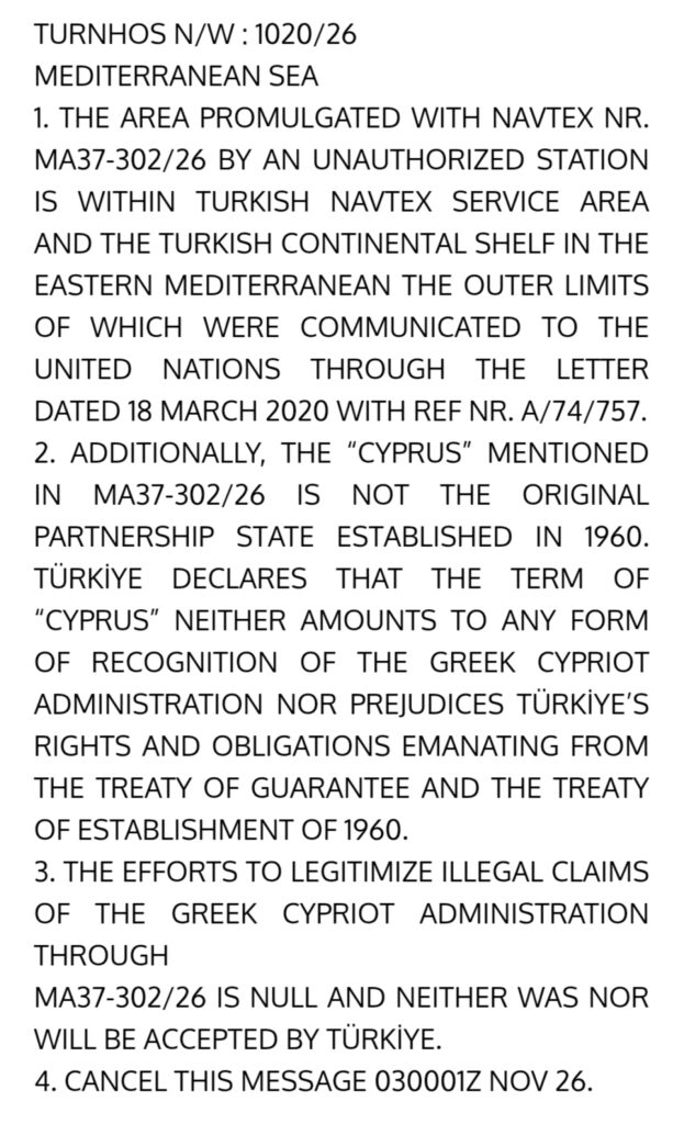
The new Turkish NAVTEX:
Cyprus has issued a NAVTEX for the announcement of operations of the vessel S/V KOBI RUEGG within the Cypriot EEZ, for the period from 21 October to 2 November, which concern geophysical surveys for the East to Med Corridor (EMC) cable system.
Turkey, shortly afterwards, issued an anti-NAVTEX in which it states that the surveys concern an area of the "Turkish continental shelf", the external boundaries of which have been notified to the United Nations in a letter dated March 18, 2020. At the same time, he claims that the Larnaca station that issued the NAVTEX is unauthorized and that the area belongs to the Turkish area of responsibility for issuing NAVTEX.
In addition, Turkey reiterates its position that 'Cyprus' does not represent the State established in 1960 and that the term 'Cyprus' does not constitute any form of recognition of the Greek Cypriot administration nor does it prejudge Turkey's rights and obligations under the Treaty of Guarantee and the 1960 Treaty of Establishment.
The Turkish NAVTEX also points out that "the attempts to legitimize illegal claims by the Greek Cypriot administration through NAVTEX are invalid and have neither been nor will be accepted by Turkey".
With these two moves, Ankara seems to be insisting on the hard line, not only in terms of the requirement to issue NAVTEX itself for all projects in the Eastern Mediterranean that it considers to fall under its own competence, but also in terms of the promotion and safeguarding of the "Blue Homeland", as reflected in the unilateral submission of coordinates and a map to the UN in 2020.
The Cypriot NAVTEX
CZC MA37
15 1300 UTC OCT 2026
RCC LARNACA/CYPRUS RADIO/5BA
NAV WRNG 302/26
MEDITERRANEAN SEA
S/V “KOBI RUEGG” (MMSI: 31100683, IMO:9713753) WILL EXECUTE GEOPHYSICAL SURVEY OPERATIONS FOR CABLE SYSTEM, EAST TO MED CORRIDOR (EMC), WITHIN REPUBLIC OF CYPRUS EEZ FROM 21 OCT 2026 UNTIL 02 NOV 2026, ALONG THE LINES (WIDTH OF LANES IS 10 NAUTICAL MILES, 5 NAUTICAL MILES ON EACH SIDE) JOINING THE POSITIONS BELOW:
LINE 1
35° 01.766’N – 30° 49.601’E
35° 01.426’N – 30° 53.910’E
34° 53.391’N – 31° 20.738’E
34° 39.128’N – 31° 38.506’E
34° 32.952’N – 31° 42.966’E
34° 21.024’N – 31° 50.407’E
34° 17.535’N – 31° 52.266’E
34° 06.103’N – 31° 56.215’E
33° 56.254’N – 32° 07.542’E
33° 48.387’N – 32° 16.300’E
33° 41.640’N – 32° 21.563’E
LINE 2
34° 44.020’N – 30° 33.733’E
34° 41.881’N – 30° 57.113’E
34° 38.633’N – 31° 03.989’E
34° 35.022’N – 31° 07.105’E
34° 24.763’N – 31° 15.807’E
34° 17.978’N – 31° 20.826’E
34° 15.763’N – 31° 22.463’E
34° 06.999’N – 31° 26.263’E
33° 53.252’N – 31° 39.631’E
33° 50.214’N – 31° 45.189’E
WIDE BERTH OF 5NM REQUESTED
CANCEL THIS MESSAGE ON 03 NOV 2026 0001 UTC
JRCC LARNACA/CYPRUS RADIO/5BA
NNNN
