Filenews 23 November 2024 - by Angelos Nicolaou

The recent floods in Valencia, Spain, with hundreds of people dead and incalculable damage, have increased concern among society about the effects of a similar natural disaster that is likely to affect Cyprus. In recent days, with rainfall and storms, flooded roads within residential areas have been observed, roads become inaccessible due to landslides due to the fall of large volumes of stones and soil as well as wood. Unfortunately, climate change and the extreme weather events it causes are increasing concern and multiplying the risk of similar disasters here too.
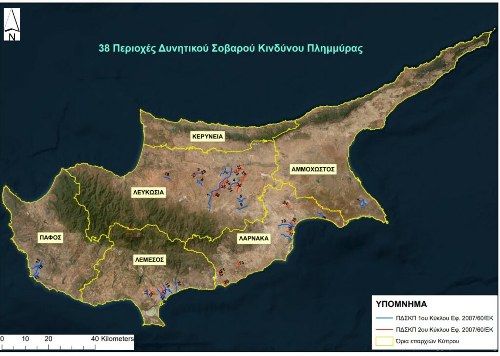
Speaking to "F", hydrologist at the Water Development Department (WDD) Costas Aristidou said that there is a risk of experiencing "Valencian-type" phenomena in Cyprus as well. As he explained, 38 dangerous areas have been identified in Cyprus that are considered as high risk, 37 of which have been identified as torrents that end up in urban areas. In the event of a flash flood, he said, we can experience such phenomena as in Valencia, since the river can carry large quantities of water. "There is a risk. In Valencia the rivers are much longer than in Cyprus. Smaller rivers that can give similar types of phenomena on a smaller scale. In the past we have had deaths and cars that were swept away," Aristidou said.
As he explained, the floods are sudden, the water descends abruptly and people cannot be warned in time. He noted that it is important at flood time not to run to save their property, as happened in Spain when they were trapped in basements trying to save their vehicles.
On his part, the director of the Fire Service, Nikos Longinos, said that the services are preparing to be ready when similar incidents occur. He explained, however, that no country can cope, not because it cannot, but there is no provision to deal with it in time. For example, he said if the grates can pull 20mm of water and it rains 100mm, inevitably the remaining 80mm could create flooding.
According to the WDD, the interruption of the continuity of riverbeds and watercourses is one of the main causes of flooding problems in Cyprus and occurs mainly due to the development of areas on the course of flows. The beds are levelled and cultivated, in other cases the bed is covered to serve urban uses, even with the construction of protective walls, effectively abolishing the riparian zone. However, in cases of extreme rainfall, the flood flow passes through the lowest altitude point, which is the location of the old riverbed and flooding problems are created.
The data do not leave very optimistic messages. Interventions in water retention projects, watercourse beds and coastal areas, constructions within the riverbeds themselves, inadequate flood protection works, roads, sidewalks, houses and entire neighbourhoods with limited or no possibilities to divert water to appropriate infrastructure, clogged wells and ditches, are just some of the "wrongs" that can lead to disaster.
The assessments become even more ominous when one finds the unsatisfactory preparation of state, municipal and community services, the reduced ability to implement a single strategic planning for flood prevention, response and management, the construction of buildings, roads, pavements and other infrastructure that do not meet all safety standards and the indifference of citizens themselves to the possible catastrophic consequences of this phenomenon. In fact, according to what scientists estimate, floods will have increased chances of occurrence in the coming years due to the unnatural effects that climate change already has on all weather phenomena worldwide. All the more so here in Cyprus, which, admittedly, is a climate change hotspot.
Flood response measures – How to avoid disaster
The Water Development Department has updated its flood risk management plan based on the European Floods Directive. The WDD flood risk management program includes prevention, protection, preparedness and restoration measures. The main of these measures are:
● Public information and awareness
● Early warning – Upgrade of early warning or flood forecasting systems
● Flood protection works
● Control of old and new infrastructure – Green infrastructure
● Natural water containment
● Regulation and control of soil sealing rate in developments and road works
● Controlled flooding of selected areas
● Restoration of riverbeds and riparian zones
● Rehabilitation and maintenance of existing infrastructure
● Management and control of illegal embankments and discharges of useless objects into rivers
● Response and rehabilitation of affected areas
● Sustainable rainwater management
Prevention recommended by the Fire Service – What citizens and local authorities should do
The Chief Fire Brigade Chief Nikos Longinos said that the change in weather conditions due to the climate crisis is a given and we all live its consequences daily. He underlined the increased preparedness of the Fire Brigade to deal with possible floods. He underlined the increased preparedness of the Fire Brigade to deal with possible floods. The most important, he noted, is prevention. Addressing the citizens, he said that they need to make sure that the manholes outside their house are not clogged, but also that the gutters of the houses are functioning normally. In case their houses are adjacent to an open plot below street level, citizens are asked to close any openings that may be located in the fencing of their premises. Furthermore, when extreme weather events are observed, citizens must limit their unnecessary movement and follow the instructions and advice of the competent authorities.
INTERACTIVE Flood Hazard Maps
High probability flood hazard map (1 in 20) - https://wdd.maps.arcgis.com/apps/webappviewer/index.html?id=479ed86d25ed4e0aaa58875111e3397f
Flood Hazard Map with average probability (1 in 100) - https://wdd.maps.arcgis.com/apps/webappviewer/index.html?id=e451e9f990bc406fb6ff5a265df521ee
Flood Hazard Map with low probability (1 in 500) - https://wdd.maps.arcgis.com/apps/webappviewer/index.html?id=1a1122301fe147f08879e2b5086c4921
Flood Hazard Map for 2080 (climate change) - https://wdd.maps.arcgis.com/apps/webappviewer/index.html?id=0a6f3f0c25c9419aa529ca7726800a6e