Filenews 15 June 2024

In the period leading up to, during and after the Turkish invasion, the United States raised satellites and monitored the wider area of Cyprus, capturing important data through photographs taken from the sky 50 years ago.
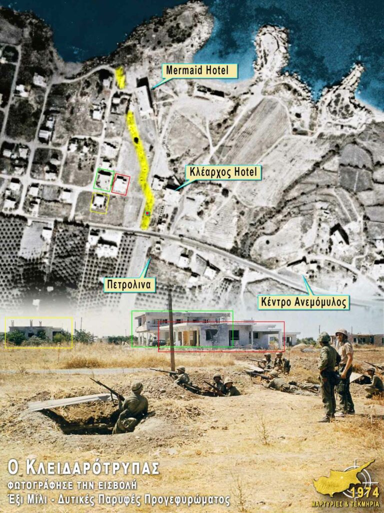
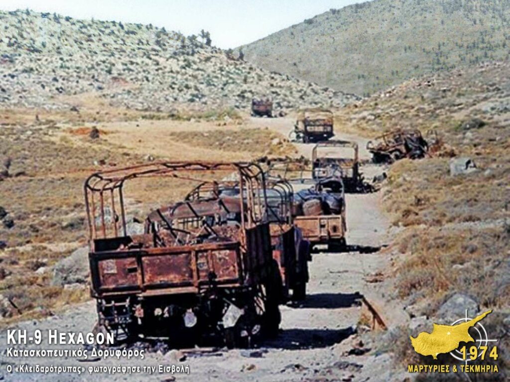
From the attack of the Turkish Air Force on a convoy of vehicles in Kontemenos (which resulted in dead and wounded) to Five Mile, where the landing of the Turks took place, to the destruction of the 181st MPP in Sychari and the prison of Adana in Turkey, where there are testimonies of missing persons.
The data came to light after research by the historical researcher and expert in geographic information systems (GIS) and remote sensing Mr. Odysseas Christou. Mr. Christou is the administrator of the PV page "1974 Testimonies & Evidence" and presented the results of his research at the conference "Military aspects of the 1974 Turkish Invasion of Cyprus", on Saturday 8 June 2024 at the Amphitheater of the University of Cyprus.
One of the satellites, codenamed "Keyhole" (KH-9 Hexagon), was taking photos from an altitude of 150 kilometers. A second satellite (KH-8 Gambit 3) was used to record the events, whose resolution reached 10 cm.
A US satellite launch is recorded on 10/4/1974 followed by another satellite mission in June, with greater resolution and whose action/tracking cycle lasts between 30-45 days. Its sister satellite, HEXACON, which takes longer to hover and was active at the time, provided a resolution of 1.2 meters.
These satellites were in orbit at the time of the coup on July 15 and the Turkish invasion on July 20. There has been a tracking gap since July 24, when on August 14 the Americans launch a special satellite to focus on selected targets and record them. This is the satellite with a resolution of 10 cm. Obviously, taking into account the launch date, he undertook to record the second phase of the Turkish invasion.
On October 29, 1974, another satellite of the HEXACON series was launched, which recorded valuable images (on November 7) of the results of the Turkish invasion.
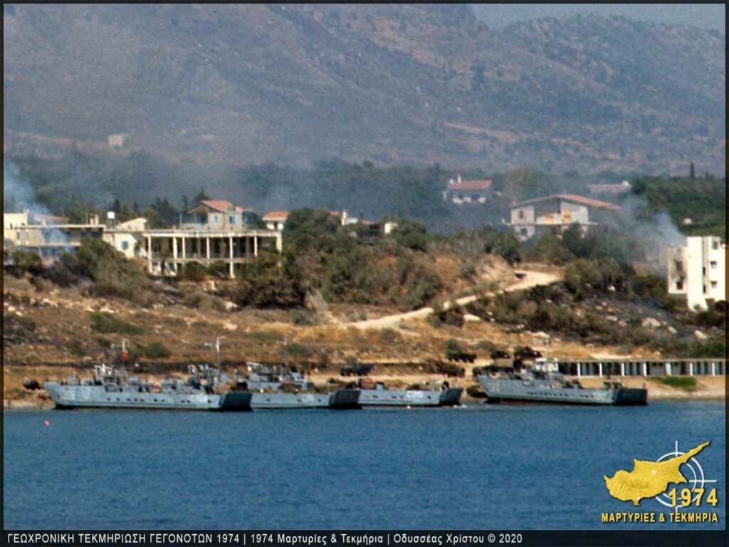
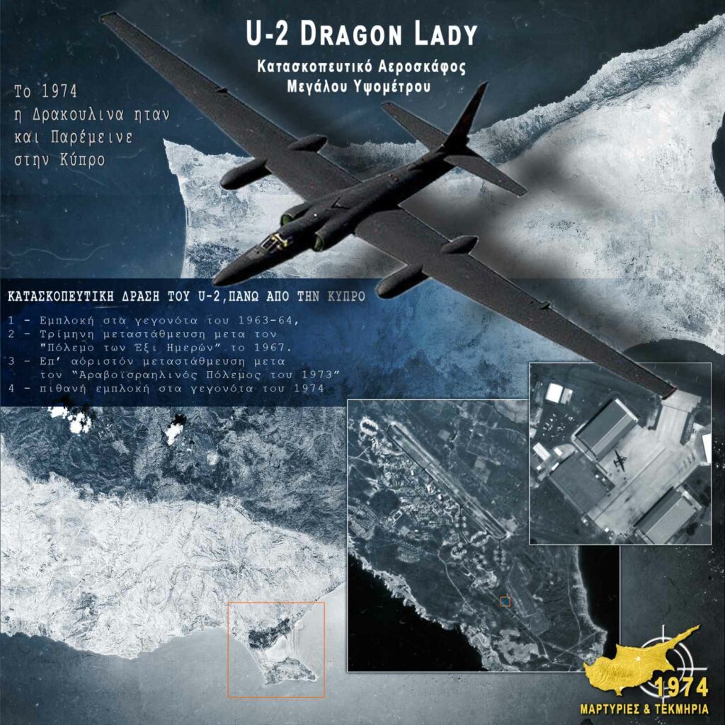
Also, from April 21, 1974, the Draculina (U-2 Dracon Lady high-altitude spy aircraft) was stationed over Cyprus. This is a squadron of U-2 Dracon Lady aircraft, with appropriate support elements, that arrived in Akrotiri, Cyprus, in the framework of operation OLIVE HARVEST (surveillance of the Egypt-Israel peace agreement).
On August 13 (a day before the start of the second Turkish invasion) the Washington Post published an article referring to the launch of a Russian satellite, which was placed in orbit over Cyprus. The news was republished in newspapers in Greece and by "Phileleftheros" on August 14, 1974 under the headline "SOVIET SATELLITE MONITORED INVASION".
The study of a series of documents as well as the secret COMIREX comments mentioned above, shows, as Mr. Christou mentions, that two American spy satellites were in orbit at the time of the events.
A) The KH-8 Gambit satellite that between 17 and 21 July photographed Cyprus while it was at the end of its mission. The data and details of this satellite's mission are classified and we can only speculate. Christou said he recorded the troop buildup on Turkey's coast before the invasion and the bridgehead after the Five Mile landing.
B) The KH-9 Hexagon satellite took pictures from an altitude of 150 km and on July 20 and 24 recorded Turkey (Adana, Instirlich, Mersin) and the whole of Cyprus. This data has been declassified and has been under investigation since 2020. As Mr Christou mentions, valuable conclusions have been drawn so far.
As he says, sometime in 2011 the Americans released the data but the process was complicated since the material was in warehouses in rolls and it was required to know exactly what it was asking for, what period it concerned and so on. From 2020 access is easier.
My goal, he says, was to locate information on historical research and the issue of missing persons, so I obtained data from the HEXACON satellite for the July 20 and 24 recordings and one on November 11.
As he explains, a photo shoot of the satellite concerns the destruction of the 181 MPP in Synhari after bombing. Smoke can be seen over Sychari, as well as the convoy moving towards the mountain, while a dead person can be seen who is still being sought today.
In November there is another photograph which refers to an embankment or exhumation.
Reference is also made to the execution of two men who were on buses from the Koutsoventis area and two others who came down from the mountain when the 181st MPP was disbanded. Smoke can also be seen from vehicles of the 33rd Commando Squadron that were struck on the morning of July 20. It also shows the mantra of the oldest missing person.
Finally, the prison of Adana can be seen from the satellite.