BBC News 11 August 2021 - by Simon King
Meteorologists have named the sixth Atlantic storm of 2021, hinting at an above-average season ahead.
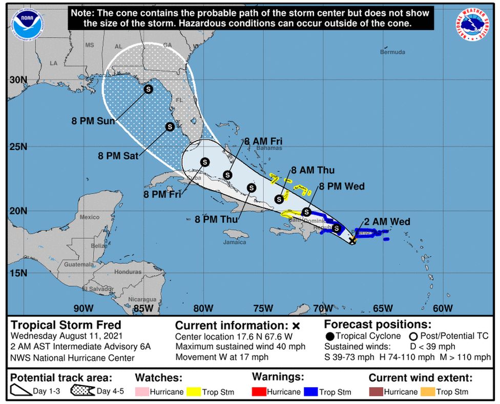
The US National Hurricane Center (NHC) has bestowed the name Tropical Storm Fred on a low pressure system barrelling through the Caribbean.
The sixth named storm of the year usually forms at the end of August.
In early July, Tropical Storm Elsa became the earliest fifth named storm on record.
In the month since, the Atlantic has been very quiet. But we're now entering what are historically the busiest months of the season.
Tropical Storm Fred will track west through the Leeward Islands before passing over many of the Caribbean's largest islands.
It is likely to remain a tropical storm as it moves towards the Bahamas and Florida later in the week.
While this season is not expected be as active as the 2020 record-breaking season, when the Greek alphabet was used to name storms for only the second time, forecasters are confident that it will still be a busy season.
"A mix of competing oceanic and atmospheric conditions generally favour above-average activity for the remainder of the Atlantic hurricane season, including the potential return of La Niña in the months ahead," said Matthew Rosencrans, lead seasonal hurricane forecaster at Noaa's Climate Prediction Center (CPC) in College Park, Maryland.
La Niña and a counterpart - El Niño - are climate patterns in the Pacific Ocean that can affect weather worldwide. During La Niña, trade winds are stronger than usual, pushing more warm water toward Asia. El Niño has the opposite effect.
In a recent update to the seasonal forecast, experts at the CPC increased the expected number of storms, hurricanes and major hurricanes by a small amount based on the latest atmospheric and Atlantic ocean conditions.
In their early August update, forecasters at Colorado State University in Fort Collins actually reduced the number of named storms expected from 20 to 18.
However, "overall, we still think that we will have an above-average season, just slightly less active than anticipated last month", Phillip Klotzbach, a research scientist at Colorado State told BBC Weather.
Tropical storm formation requires a number of different environmental parameters, such as a sea surface temperature above 26C and weak wind shear to come together.
Forecasters look at these elements, along with larger natural climatic patterns such as El Niño and La Niña, to make predictions.
The above average forecast is therefore in part due to slightly warmer-than-average sea surface temperatures in the Atlantic and wind shear anomalies over the Caribbean and tropical Atlantic that are slightly weaker than normal.
There is a potential return to La Niña conditions in the months ahead, which would also signal to increased tropical storm development.
How will climate change impact the hurricane season?
With warmer oceans you get more fuel for a tropical storm or hurricane to develop.
In the UN's latest IPCC report - which details the latest thinking in climate science - it says of tropical cyclones: "It is likely that the frequency of rapid intensification in tropical cyclones has increased globally over the last 40 years."
The report goes on to conclude with "high confidence" that the proportion of intense tropical cyclones will increase on a global scale with increasing warming.
In other words, the tropical cyclones that form are likely to become more intense, which if they hit land, will bring more impacts.
As for the number of storms - while we've recently had active seasons - the IPCC report suggests with "medium confidence" that the "global frequency of tropical cyclone formation will decrease or remain unchanged with increasing global warming".

